Chesapeake Bay Agriculture
Using NASA Earth Observations to Map Winter Cover Crop Conservation Performance in the Chesapeake Bay Watershed
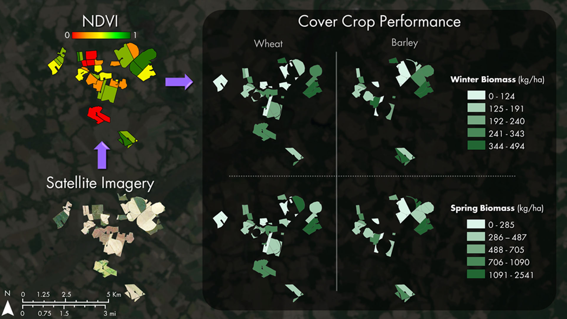
Winter cover crops are an essential component of adaptive management practices to reduce soil erosion, nutrient loss, and nutrient leaching leading to water quality degradation. The Maryland Department of Agriculture (MDA) and Chesapeake Bay partners (US Geological Survey and USDA Agricultural Research Service) oversee a cost-sharing program that offers subsidies to farmers enrolled in the winter cover crop program. The effectiveness of mitigating soil and nutrient loss varies by crop species, planting date, planting method, prior crop species, manure inputs, and growing degree days. In addition to field related factors, landscape factors may also influence winter crop performance. While methods to quantify crop performance are available, they are not automated for timely analysis. This study used Landsat 5, Landsat 8, and Sentinel-2 imagery to quantify crop performance using vegetation indices to estimate biomass and nitrogen uptake in three counties on the Eastern Shore of Maryland in the Chesapeake Bay, in addition to one western county, all located in Maryland. The methods developed in this project automate acquisition of annual satellite imagery and calculation of winter cover crop metrics. The crop performance data produced facilitates analysis for the MDA to monitor winter cover crop efficiencies at varying scales, for example by identifying underperforming versus satisfactory cover crop fields, as well as those with high biomass.
Project Video:
Catchment in the Rye: Conservation of the Chesapeake Bay
- Location
- NASA Goddard Space Flight Center
- Term
- Spring 2017
- Partner(s)
- Maryland Department of Agriculture, Office of Resource Conservation
USGS, Eastern Geographic Science Center
USDA, Agricultural Research Service, Hydrology and Remote Sensing Laboratory
US Environmental Protection Agency, Chesapeake Bay Program - NASA Earth Observations
- Landsat 5, TM
Landsat 8, OLI
Sentinel-2, MSI - Team
- Dr. Sunita Yadav-Pauletti (Project Lead)
John Fitz
Sean McCartney
Perry Oddo
Alison Thieme - Advisor(s)
- Dr. W. Dean Hively (USGS Eastern Geographic Science Center)
Dr. Greg McCarty (USDA, Agricultural Research Service, Hydrology and Remote Sensing Laboratory)