East Africa Disasters II
Assessing Landslide Characteristics and Developing Susceptibility and Exposure Maps in Malawi
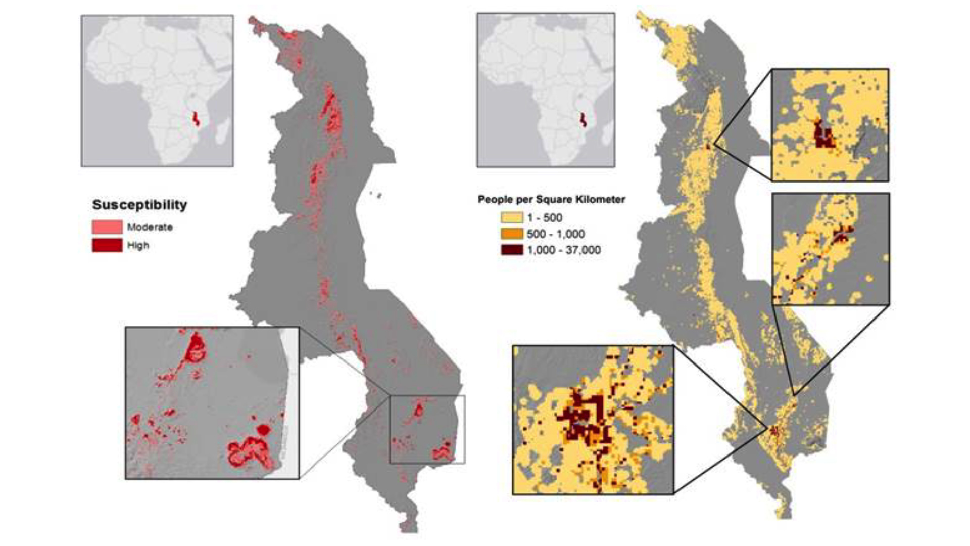
Malawi has become increasingly prone to landslides in the past few decades. This can be attributed to the terrain, types of soil and vegetation, increased human interference, and heavy flooding after long periods of drought. In addition to the floods and droughts, landslides cause extra stress to farmlands, thus exacerbating the current food security crisis in the country. It can be difficult to pinpoint just how many people are affected by landslides in Malawi because landslides often occur in rural areas or are grouped with other disasters, such as floods or earthquakes. This project created a Landslide Susceptibility Map to assess landslide-prone areas in Malawi using variables such as slope, distance to roads, soil type, land cover type, and precipitation. These variables were derived using imagery from Landsat 8 Operational Land Imager (OLI), Shuttle Radar Topography Mission Version 3 (SRTM-v3), Global Precipitation Measurement (GPM), and Tropical Rainfall Measuring Mission (TRMM) satellites. Furthermore, this project created Landslide Exposure Maps to estimate how much of the local population lives in susceptible areas by intersecting population data with the Landslide Susceptibility Maps. Additionally, an assessment of GPM and TRMM precipitation measurements was generated to better understand the reliability of both measurements for landslide monitoring. Finally, this project updated NASA SERVIR's Global Landslide Catalog (GLC) for Malawi by using WorldView data from Google Earth and Landsat 8 OLI. These end products were used by NASA SERVIR and the Regional Centre for Mapping of Resources for Development (RCMRD) for aiding in disaster management throughout Malawi
- Location
- NASA Marshall Space Flight Center
- Term
- Summer 2016
- Partner(s)
- Regional Centre for Mapping of Resources for Development (RCMRD)
NASA SERVIR Coordination Office at MSFC
NASA SERVIR Applied Sciences Team at NASA GSFC - NASA Earth Observations
- Landsat 5, TM
Landsat 8, OLI
GPM, IMERG
TRMM, PR
SRTM-v3 - Team
- Maggi Klug (Project Lead)
Max Grossman
Jordan Cissell - Advisor(s)
- Dr. Jeffrey Luvall (NASA at National Space Science Technology Center)
Dr. Robert Griffin (University of Alabama in Huntsville)
Eric Anderson (NASA SERVIR Coordination Office at MSFC)
Project Video