Gunnison Agriculture
Mapping Spruce Beetle Outbreak Severity and Distribution in Gunnison National Forest Using Landsat and Integrative Spatial Modelling
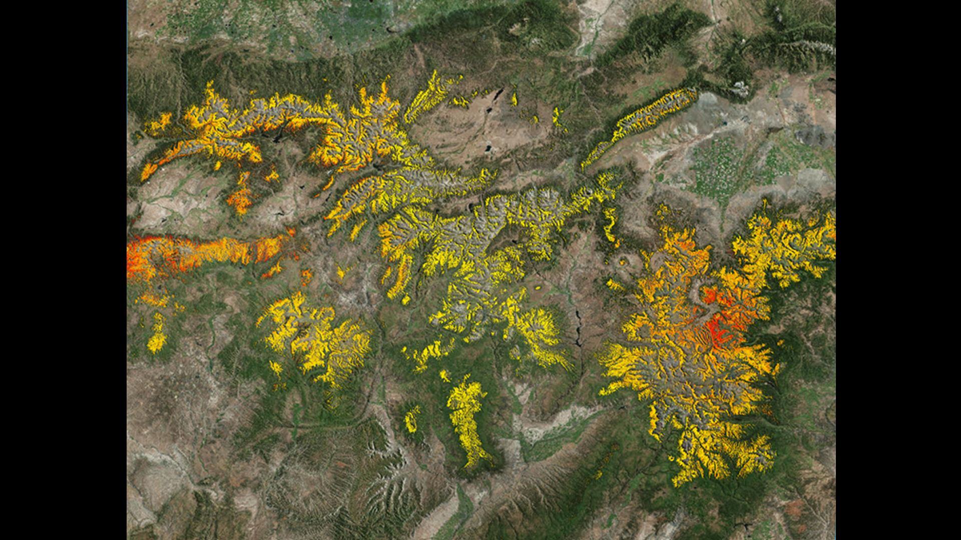
Over the last fifteen years Colorado forests have experienced epidemic bark beetle outbreaks with increasing severity. These outbreaks affect forest health, wildlife habitat, wildfire regimes, and the safety of recreational forest users. The impacts of epidemic outbreaks are of great concern to land managers and project partners at the US Forest Service (USFS) who are working to maintain ecological integrity and safe public access in national forest lands. Since the decline of the Mountain Pine Beetle (Dendroctonus ponderosae), the spruce beetle (Dendroctonus rufipennis) epidemic has become the longest ongoing outbreak in the state. This project utilizes Landsat 8 OLI & TIRS, Landsat 5 TM, NAIP imagery, and forest health indices to produce spruce mortality data. These combined datasets are utilized in an integrative spatial model to produce fine scale maps of spruce mortality across the Rocky Mountains of Colorado for the years 2013 and 2015. This novel methodology and the resulting maps will augment the limited spruce beetle spatial data currently available for Colorado forests and potentially provide an improvement upon existing maps used by our project partners.
- Location
- USGS at Colorado State University
- Term
- Spring 2016
- Partner(s)
- Bioenergy Alliance Network of the Rockies (BANR)
Montana State University, Spatial Sciences Center
Colorado State University, Natural Resource Ecology Laboratory (NREL)
USDA Forest Service, Gunnison Ranger District
USDA Forest Service, Rocky Mountain Research Station - NASA Earth Observations
- Landsat 8, OLI & TIRS
Landsat 5, TM
SRTM V2 - Team
- Eric Rounds (Project Lead)
Sarah Carroll
Oliver Miltenberger
Peder Engelstad - Advisor(s)
- Dr. Paul Evangelista (Natural Resources Ecology Lab, Colorado State University)
Tony Vorster (Bioenergy Alliance Network of the Rockies)
Brian Woodward (DEVELOP – Fort Collins Center Lead)
Project Video