Alabama Ecological Forecasting
Assessing Southern Pine Beetle Epidemics in Alabama's Bankhead National Forest Using NASA Earth Observations
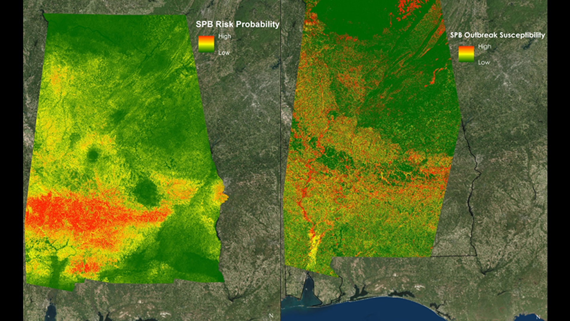
The Southern Pine Beetle (SPB), Dendroctonus frontalis, is an opportunistic species that attacks stressed trees weakened by drought, storm damage, or fire. In 2000, about 18,600 acres of pine forest were damaged throughout the Bankhead National Forest due to SPB. The United States Department of Agriculture (USDA) Forest Service currently uses expensive manned aerial surveys, such as aerial photography and Light Detection and Ranging (LiDAR), as well as Moderate Resolution Imaging Spectroradiometer (MODIS) ForWarn and Forest Disturbance Monitor data to help with mitigation efforts. This project used remotely sensed data to identify SPB infested areas throughout Alabama and determine outbreak patterns. Aqua/Terra MODIS were used to derive a Normalized Difference Vegetation Index (NDVI) and a Green-Red Vegetation Index (GRVI) to show vegetation health and a Normalized Moisture Difference Index (NMDI) to show the surrounding drought conditions. Shuttle Radar Topography Mission Version 2 (SRTM-v2) Digital Elevation Models (DEM) were used to understand how elevation, slope, and aspect affect SPB susceptibility. Present SPB data and various environmental variables were analyzed using the Princeton University Maximum Entropy model (MaxEnt) to assess areas susceptible to a SPB outbreak by creating a SPB Prediction Map for 2050. Additionally, this project determined where mitigation efforts should be focused by creating a Near Real-Time SPB Susceptibility Model. A Historical SPB Coverage Map was created to understand patterns of previous attacks. The USDA Forest Service used these methodologies and maps to reduce costs and time associated with SPB suppression in Bankhead National Forest and Alabama.
- Location
- NASA Marshall Space Flight Center
- Term
- Spring 2016
- Partner(s)
- USDA Forest Service, Bankhead District Ranger
USDA Forest Service, SPB Coordinator
USDA Forest Service, Forest Health Monitoring Coordinator - NASA Earth Observations
- SRTM-v2, C-Band
Landsat 5, TM
Landsat 8, OLI - Team
- Ryan Schick (Project Lead)
Kelsey Herndon
Maggi Klug
Leigh Sinclair - Advisor(s)
- Dr. Jeffrey Luvall (NASA at the National Space Science Technology Center)
Dr. Robert Griffin (University of Alabama in Huntsville)
Project Video